The search has to be between 2 and 50 characters


Products in this weekly ad
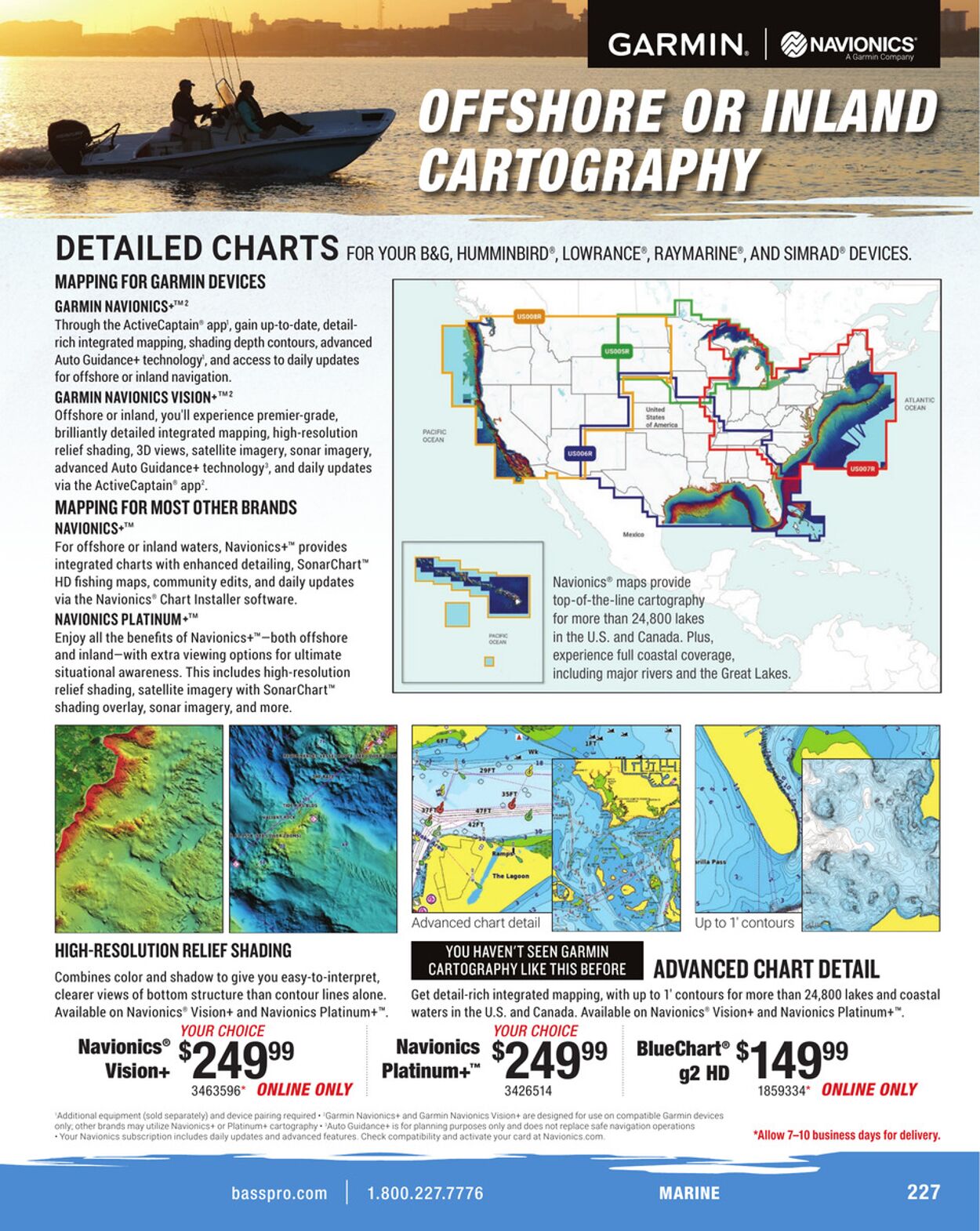
GARMIN. | @navionics DETAILED CHARTS ror your bac, HuMMINBIRD®, LOWRANCE®, RAYMARINE®, AND SIMRAD® DEVICES. MAPPING FOR GARMIN DEVICES GARMIN NAVIONICS+™? Through the ActiveCaptain® app’, gain up-to-date, detail- rich integrated mapping, shading depth contours, advanced Auto Guidance+ technology’, and access to daily updates for offshore or inland navigation. GARMIN NAVIONICS VISION+™? Offshore or inland, you'll experience premier-grade, brilliantly detailed integrated mapping, high-resolution rome relief shading, 3D views, satellite imagery, sonar imagery, advanced Auto Guidance+ technology’, and daily updates via the ActiveCaptain® app’. MAPPING FOR MOST OTHER BRANDS NAVIONICS+™ For offshore or inland waters, Navionics+™ provides integrated charts with enhanced detailing, SonarChart™ HD fishing maps, community edits, and daily updates Navionics® maps provide via the Navionics® Chart Installer software. top-of-the-line cartography NAVIONICS PLATINUM+™ for more than 24,800 lakes Enjoy all the benefits of Navionics+™—both offshore : in the U.S. and Canada. Plus, and inland—with extra viewing options for ultimate experience full coastal coverage, situational awareness. This includes high a including major rivers and the Great Lakes. relief shading, satellite imagery with SonarChart™ shading overlay, sonar imagery, and more. me Se) Advanced chart detail [E 2 xe Up to 1’ contours HIGH-RESOLUTION RELIEF SHADING SUMS ay ce) Combines color and shadow to give you easy-to-interpret, Ta ais ADVANCED CHART DETAIL clearer views of bottom structure than contour lines alone. _ Get detail-rich integrated mapping, with up to 1’ contours for more than 24,800 lakes and coastal Available on Navionics® Vision+ and Navionics Platinum+™. waters in the U. A He Pte Available on Navionics’ Vision+ and Navionics Platinum+™. YOUR CHOICE Navionics° 99 Navionics 99 nae 99 Vision+ 5249 Platinum+" $249 = 49 3463596" ONLINE ONLY 3426514 1859334" ONLINE ONLY Garmin “Allow 7-10 business days for delivery. basspro.com BRL ra Aa ads) UV


| Name | Details |
|---|