The search has to be between 2 and 50 characters

Advertisement
Advertisement
Advertisement

Current weekly ad Bass Pro - Valid from 12/09 to 12/23 - Page nb 227

Advertisement
Advertisement
Advertisement


Advertisement
Weekly ad Bass Pro 12/09/2025 - 12/23/2025
Weekly ad Hobby Lobby - hobby lobby Nov 23, 2023 - Nov 25, 2023
Hobby Lobby - hobby lobby
Nov 23, 2023 - Nov 25, 2023
Weekly ad Lunardi's Market - Lunardis Aug 15, 2023 - Aug 21, 2023
Lunardi's Market - Lunardis
Aug 15, 2023 - Aug 21, 2023
Weekly ad P.C. Richard & Son - PC Richard & Son Jun 1, 2023 - Jun 30, 2023
P.C. Richard & Son - PC Richard & Son
Jun 1, 2023 - Jun 30, 2023
Weekly ad Food Depot - food depot Oct 16, 2023 - Nov 22, 2023
Food Depot - food depot
Oct 16, 2023 - Nov 22, 2023
See next flyer
Advertisement
Advertisement


Advertisement

Products in this weekly ad

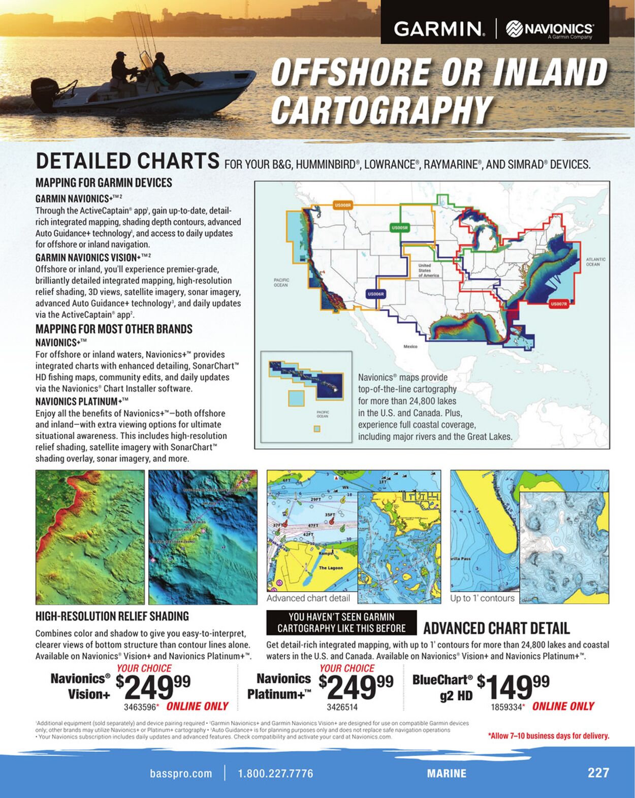
GARMIN. | @navionics DETAILED CHARTS ror your bac, HuMMINBIRD®, LOWRANCE®, RAYMARINE®, AND SIMRAD® DEVICES. MAPPING FOR GARMIN DEVICES GARMIN NAVIONICS+™? Through the ActiveCaptain® app’, gain up-to-date, detail- rich integrated mapping, shading depth contours, advanced Auto Guidance+ technology’, and access to daily updates for offshore or inland navigation. GARMIN NAVIONICS VISION+™? Offshore or inland, you'll experience premier-grade, brilliantly detailed integrated mapping, high-resolution rome relief shading, 3D views, satellite imagery, sonar imagery, advanced Auto Guidance+ technology’, and daily updates via the ActiveCaptain® app’. MAPPING FOR MOST OTHER BRANDS NAVIONICS+™ For offshore or inland waters, Navionics+™ provides integrated charts with enhanced detailing, SonarChart™ HD fishing maps, community edits, and daily updates Navionics® maps provide via the Navionics® Chart Installer software. top-of-the-line cartography NAVIONICS PLATINUM+™ for more than 24,800 lakes Enjoy all the benefits of Navionics+™—both offshore : in the U.S. and Canada. Plus, and inland—with extra viewing options for ultimate experience full coastal coverage, situational awareness. This includes high a including major rivers and the Great Lakes. relief shading, satellite imagery with SonarChart™ shading overlay, sonar imagery, and more. me Se) Advanced chart detail [E 2 xe Up to 1’ contours HIGH-RESOLUTION RELIEF SHADING SUMS ay ce) Combines color and shadow to give you easy-to-interpret, Ta ais ADVANCED CHART DETAIL clearer views of bottom structure than contour lines alone. _ Get detail-rich integrated mapping, with up to 1’ contours for more than 24,800 lakes and coastal Available on Navionics® Vision+ and Navionics Platinum+™. waters in the U. A He Pte Available on Navionics’ Vision+ and Navionics Platinum+™. YOUR CHOICE Navionics° 99 Navionics 99 nae 99 Vision+ 5249 Platinum+" $249 = 49 3463596" ONLINE ONLY 3426514 1859334" ONLINE ONLY Garmin “Allow 7-10 business days for delivery. basspro.com BRL ra Aa ads) UV


Latest weekly ads

Weekly ads selected for you

Advertisement
GARMIN. | @navionics DETAILED CHARTS ror your bac, HuMMINBIRD®, LOWRANCE®, RAYMARINE®, AND SIMRAD® DEVICES. MAPPING FOR GARMIN DEVICES GARMIN NAVIONICS+™? Through the ActiveCaptain® app’, gain up-to-date, detail- rich integrated mapping, shading depth contours, advanced Auto Guidance+ technology’, and access to daily updates for offshore or inland navigation. GARMIN NAVIONICS VISION+™? Offshore or inland, you'll experience premier-grade, brilliantly detailed integrated mapping, high-resolution rome relief shading, 3D views, satellite imagery, sonar imagery, advanced Auto Guidance+ technology’, and daily updates via the ActiveCaptain® app’. MAPPING FOR MOST OTHER BRANDS NAVIONICS+™ For offshore or inland waters, Navionics+™ provides integrated charts with enhanced detailing, SonarChart™ HD fishing maps, community edits, and daily updates Navionics® maps provide via the Navionics® Chart Installer software. top-of-the-line cartography NAVIONICS PLATINUM+™ for more than 24,800 lakes Enjoy all the benefits of Navionics+™—both offshore : in the U.S. and Canada. Plus, and inland—with extra viewing options for ultimate experience full coastal coverage, situational awareness. This includes high a including major rivers and the Great Lakes. relief shading, satellite imagery with SonarChart™ shading overlay, sonar imagery, and more. me Se) Advanced chart detail [E 2 xe Up to 1’ contours HIGH-RESOLUTION RELIEF SHADING SUMS ay ce) Combines color and shadow to give you easy-to-interpret, Ta ais ADVANCED CHART DETAIL clearer views of bottom structure than contour lines alone. _ Get detail-rich integrated mapping, with up to 1’ contours for more than 24,800 lakes and coastal Available on Navionics® Vision+ and Navionics Platinum+™. waters in the U. A He Pte Available on Navionics’ Vision+ and Navionics Platinum+™. YOUR CHOICE Navionics° 99 Navionics 99 nae 99 Vision+ 5249 Platinum+" $249 = 49 3463596" ONLINE ONLY 3426514 1859334" ONLINE ONLY Garmin “Allow 7-10 business days for delivery. basspro.com BRL ra Aa ads) UV

Most popular weekly ads

Advertisement
Advertisement

If you continue to browse this website, you accept the use of cookies.

Name Details